


By Staff Reporter | Westferry Times PUBLISHED: Monday, May 4, 2026 | London
To understand the volatile nature of the border between Pakistan and Afghanistan, one must look not at current politics, but at an 1893 agreement signed in a Kabul palace. It is here that colonial geography first collided violently with the spiritual and cultural unity of the region, creating an enduring geopolitical fault line.
How a British Line became a ‘Knife’ in the pashtun heartland
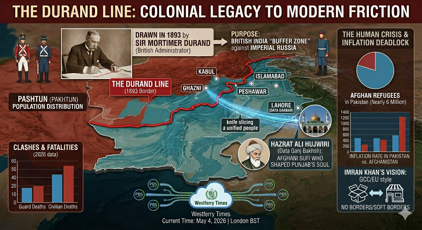
The “Durand Line” (the 2,640 km border established in 1893) is named after Sir Mortimer Durand, a British colonial administrator. Its drawing was a strategic maneuver by the British Empire at the height of the ‘Great Game’ with Imperial Russia.
The purpose was explicit: to create a secure “Buffer Zone” for British India, keeping Russian forces far from the lucrative crown jewel.
However, the line was drawn with almost no regard for local populations. It acted, as many Pashtuns describe it, like a “Knife”, slicing directly through the centuries-old traditional lands of the Pashtun tribes (the Pakhtuns/Afghans). Groups once bound by blood, marriage, and trade were suddenly separated by a colonial construct.
The Current Friction: Control, Violence, and Political posturing
Today, the 2026 environment remains one of intense friction. Clashes, often resulting in the deaths of border guards and civilians on both sides, are driven by a singular conflict: The Struggle for Control.
- Pakistan’s Perspective (The Desire for a Safe Border): Pakistan seeks to formalize and secure the border to regulate migration and counter transnational terrorism (e.g., TTP/IS-K).
- Afghanistan’s Perspective (The Question of Sovereignty): No Afghan government—whether democratic, republican, or Taliban—has ever formally recognized the line as an international border. They view it as a colonial line that partitioned their nation.
The Human Cost of the Blame Game
This political deadlock has led to dynamic human suffering. The region is currently home to nearly 6 million Afghan refugees, many of whom have lived in Pakistan for generations. Rather than being offered security and inclusion, in 2026, many are facing enhanced restrictions and a political “blame game.”
Analytically, this strategy has done little to resolve inflation or poverty in either nation. Instead, it fosters an environment of blame, manipulation, and hate—characteristics that spiritual leaders, including Pakistan’s former leader Imran Khan, have argued are contrary to the true unifying tenets of shared faith.
Reference & Historical Check: The Buffer Zone terms
The primary historical rationale (British data, 1890-1895) confirms the land was explicitly mapped as a geopolitical firewall against Russian expansionism. While Afghan rhetoric sometimes alludes to a “100-Year Return Clause,” most formal academic references confirm the 1893 agreement contains no expiry date or provision for returning the territory. It was intended as a permanent boundary.
Spiritual Unity vs. Worldly Division: A ‘Westferry’ Reflection
If current policy seems driven by “worldly benefit” and geopolitical control, the historic soul of the region tells a different story. The Durand Line may separate the geography, but it has never separated the spirit.
Nowhere is this unity more evident than in Lahore, Pakistan, at Data Darbar.
This is the shrine of Hazrat Ali Hujwiri (Data Ganj Bakhsh), the 11th-century Sufi saint and one of South Asia’s most revered spiritual fathers. Yet, Hazrat Hujwiri was not Punjabi; he was a scholar from Ghazni (in modern-day Afghanistan).
He settled in Lahore, spreading a philosophy rooted in divine love, respect, and inclusion. The daily sight of millions of Punjabis and Pashtuns—together at his tomb—provides an enduring 24/7 testament that the division sought by maps is not the default state of the soul.
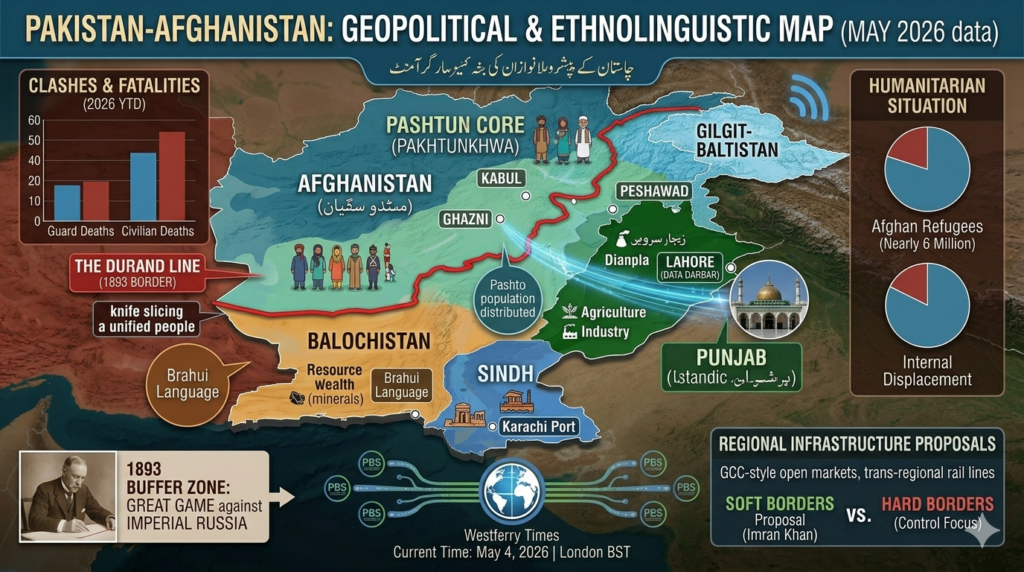
Visualising the Durand Line conflict
Infographic 1: From Colonial Map to modern crisis
This graphic visualizes the 1893 border-drawing process. It shows Sir Mortimer Durand physically drawing the line that created the “British India Buffer Zone,” and contrasts this with modern graphs of Pashtun tribes on both sides and current conflict statistics.
Infographic 2: Geopolitics vs. Spiritual Unity
This visualization maps the core dilemma: a red geographical map of the Durand Line is overlaid with a glowing blue representation of the common market, shared language, and the shared Sufi pathways linking cities like Ghazni, Kabul, and Lahore.